As the race toward fully autonomous vehicles (AV) accelerates, the competition between LiDAR and Radar continues to shape the future of self-driving technology. Both are essential for ADAS, but each has its own strengths and weaknesses.
According to MarketsandMarkets, the global automotive LiDAR market is projected to grow from $1.19 billion in 2024 to $9.59 billion by 2030, at an impressive CAGR of 41.6%, driven by the demand for high-resolution 3D mapping. Meanwhile, the automotive Radar market is expected to expand from $6.6 billion in 2024 to $33.6 billion by 2030, with a CAGR of 31.1%, by virtue of its affordability and superior weather performance.
In this article, we’ll dive into how LiDAR and Radar work, compare their advantages and limitations, and explore their applications in autonomous driving. Could one technology outpace the other, or will the future of self-driving cars depend on a combination of both? Let’s find out LiDAR vs radar in autonomous vehicle races.
Read more: Autonomous Vehicle Trends: What’s Next for Autonomous Driving?
| Features | LiDAR | Radar |
| How it works | Emits laser beams (light) and measures the time it takes to return. | Emits radio waves and measures the time it takes to return. |
| Wave type | Laser (light waves) | Radio waves |
| Wavelength | Shorter (nanometers) | Longer (centimeters to meters) |
| Resolution capabilities | High | Lower |
| Range | Short to medium | Longer |
| Accuracy | High | Lower |
| Weather condition | Affected by heavy rain, fog, snow | Less affected by weather |
| Cost | High | Lower |
| Data output | High-density 3D point clouds | Range, velocity, and direction information |
| Typical applications in AVs | Object detection, mapping, localization, pedestrian detection. | Long-range object detection, adaptive cruise control, blind-spot monitoring. |
What is LiDAR?
How does LiDAR work?
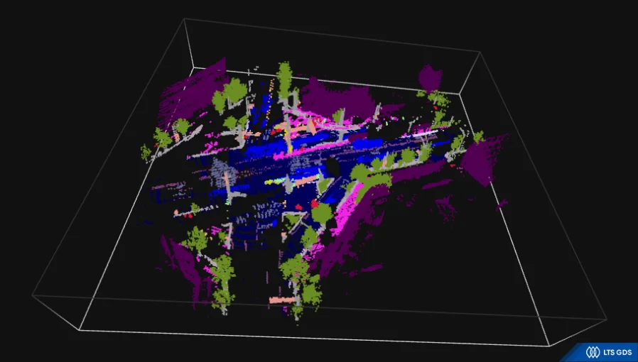
LiDAR stands for Light Light Detection and Ranging, is a remote sensing method that uses light in the form of a pulsed laser to measure distances to objects. It emits laser pulses and measures the time it takes for the reflected light to return. This “time-of-flight” information is then used to calculate the distance to the object.
By rapidly scanning the environment with these laser pulses, LiDAR creates a 3D map of the surrounding environment and provides highly detailed information about the shape, size, and location of objects.
What Is LiDAR?
Common types of LiDAR used in autonomous vehicles
1. Mechanical LiDAR: This was the earliest form of LiDAR used in autonomous driving. It uses rotating mirrors and lasers to provide a 360-degree field of view. However, they tend to require a slower data acquisition rate compared to other types because they are larger and heavier.
2. Solid-state LiDAR: This type of LiDAR uses electronic scanning (optical phased arrays or micro-mirrors) rather than moving parts, making it more durable and cheaper. They have various implementation methods, including:
- Microelectromechanical systems (MEMs) LiDAR: uses tiny mirrors that are moved precisely by electrical signals to direct the laser beam.
- Flash LiDAR: functions like a flash, illuminating the entire scene with a single laser pulse and capturing the reflected light with a highly sensitive sensor array. This enables instantaneous 3D imaging but may have limitations in range and resolution.
- Frequency-modulated continuous wave (FMCW) LiDAR: transmits a continuous laser beam whose frequency is modulated over time. By analyzing the difference in frequency between the transmitted and received light, the distance to an object can be determined.
What is Radar?
How does Radar work?
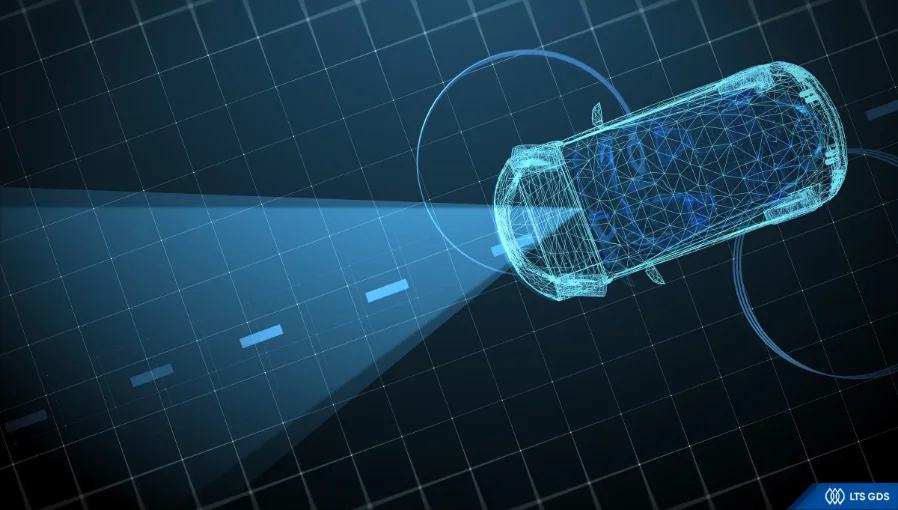
Radar, or Radio Detection and Ranging, is another sensing technology that uses radio waves to detect and measure the positions of objects instead of using light.
Radar system emits radio signals that bounce off objects in its path and the sensor then receives the reflected signal. This data can determine the distance, speed, and direction of the objects and contribute to predicting their future movement and trajectory.
Unlike LiDAR, Radar is less affected by adverse weather conditions.
What Is Radar?
Common types of Radar used in autonomous vehicles
1. Impulse RADAR: emits short pulses of radio waves and measures the time it takes for the pulses to return to determine the distance to an object. It is relatively simple to implement but can be susceptible to signal interference.
2. Frequency-modulated continuous wave (FMCW) RADAR: this is the most common type of Radar used in automotive applications. It transmits a continuous signal whose frequency is modulated over time. The difference in frequency between the transmitted and received signals will define both the distance and relative speed of an object.
3. 4D Imaging RADAR: This advanced type of Radar goes beyond traditional Radar by providing not only range, velocity, and angle information but also elevation data. Multiple antennas and sophisticated signal processing techniques are utilized to achieve this enhanced level of perception. This creates a more comprehensive “4D” environment image, leading to better tracking and detection. It is gaining importance in autonomous vehicles as it enhances perception in harsh weather and complex environments.
Key Differences Between LiDAR vs Radar
Both LiDAR and Radar are the key sensing technologies used in autonomous driving, but they have distinct differences that make them suitable for different purposes. Let’s compare the differences (LiDAR vs radar) in the following aspects.
Key Differences Between Lidar vs Radar
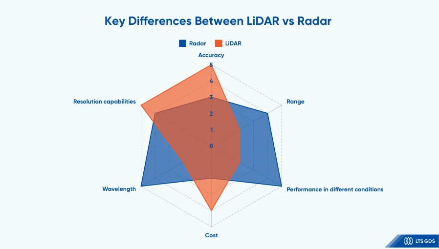
Wavelength
The biggest difference lies in the type of electromagnetic radiation each uses.
LiDAR employs light waves, typically in the near-infrared or visible spectrum (wavelengths in the nanometer range). This short wavelength allows for highly precise measurements and detailed object recognition.
Meanwhile, Radar uses radio waves, which have much longer wavelengths (millimeter to meter range). These longer wavelengths are less susceptible to atmospheric interference, but they also result in lower resolution.
Resolution capabilities
LiDAR’s use of short-wavelength light enables it to achieve higher resolution by creating detailed 3D point clouds of the environment. LiDAR can detect the shape and size of objects with high accuracy.
Radar, while highly effective at detecting objects and measuring their distance, struggles to capture fine details. Its lower resolution makes it more challenging to classify objects with the same level of precision as LiDAR.
Range
While modern LiDAR systems can detect objects up to 200 meters, radar uses radio waves to detect objects over 250 meters. This longer range can be useful in highway driving scenarios, providing the autonomous vehicle with ample time to react to distant obstacles.
However, keep in mind that range is not the only factor, the quality of the data received within that range is equally important. This means that even if a radar system has a long-range, it may not be able to accurately detect and track targets if the data it receives is of poor quality.
Weather conditions
Radar offers an advantage over LiDAR in the light of its use of radio waves, which are far less susceptible to adverse weather conditions than LiDAR’s reliance on light waves.
LiDAR’s effectiveness is significantly affected by atmospheric disturbances like heavy rain, fog, snow, and dust. These conditions can scatter and absorb the laser beams used by LiDAR, reducing its performance.
In contrast, radar utilizes longer-wavelength radio waves. These waves can penetrate fog and light rain with relative ease, allowing the radar to maintain functionality even in conditions that would weaken LiDAR.
Data output
LiDAR generates massive amounts of data in the form of dense 3D point clouds for representing the surrounding environment, while radar offers range, velocity, and direction information for functions like adaptive cruise control.
The different data characteristics influence the overall system architecture and processing requirements of the autonomous vehicle.
Cost
LiDAR systems have been significantly more expensive than radar systems before.
This higher cost has been a major barrier to the widespread adoption of LiDAR in autonomous vehicles.
That said, advancements in manufacturing and technology are gradually driving down the cost of LiDAR. While still generally more expensive than radar, the price gap is narrowing.
Radar remains a more cost-effective solution, especially for applications where high resolution is not a key factor.
In autonomous vehicles, LiDAR and radar often work together in a sensor fusion system. This combination enhances the overall safety and reliability of self-driving systems, which contributes to accelerating advancements in the autonomous driving race.
Practical Applications of LiDAR and Radar in Autonomous Driving
LiDAR applications in autonomous vehicles
LiDAR plays an important role in autonomous vehicle perception by providing highly detailed 3D maps of the surrounding environment. Its precise distance measurements and high-resolution point clouds facilitate:
Obstacle detection: tracks obstacles and vehicles to maintain safe distances
Road sign recognition: identifies road signs, traffic signals, and road markings
Traffic analysis: analyzes real-world traffic scenarios
Lane detection: precisely detects road lanes
Hazard analysis: recognizes hazards in real-time
Moreover, LiDAR contributes to the localization function, helping vehicles accurately pinpoint their position within the mapped environment.
Radar applications in autonomous vehicles
Radar is used for long-range object detection, especially in adverse weather conditions. Its ability to precisely measure distance and relative speed makes it essential for
- Adaptive cruise control,
- Collision avoidance,
- Blind-spot monitoring,
- Emergency braking.
Though its resolution is lower than LiDAR, radar’s robust performance in challenging conditions creates a crucial backup, ensuring reliable data for advanced driver-assistance systems (ADAS).
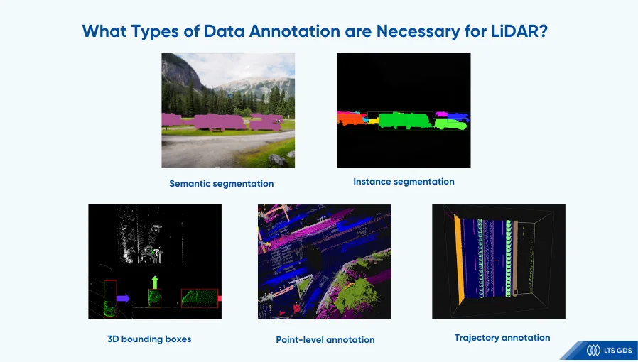
What Types of Data Annotation are Necessary for LiDAR?
LiDAR generates 3D point clouds to build a visual data environment that helps ADAS systems make safe predictions and decisions on the road, so it requires high-quality datasets.
What Types of Data Annotation are Necessary for LiDAR?
Several common types of data annotation for LiDAR are
- 3D bounding boxes,
- Semantic segmentation,
- Instance segmentation,
- Point-Level Annotation,
- Trajectory Annotation.
Read more: LiDAR Annotation: Current Landscape and Future Directions
Each type of annotation serves different project needs, contributing to high project volumes and extended timelines that last for years.
To choose the most suitable and effective annotation project, LiDAR vendors need to research carefully before signing any contract.
If automotive leaders need further detailed information, please contact us to receive advice from our experts with more than 9 years of experience in implementing data annotation projects for the automotive industry.
Read more: The Role of Data Annotation in the Automotive Industry

Need Expert Assistance with Your ADAS Projects
FAQ about LiDAR vs Radar in the Autonomous Vehicle Race
1. Which is better, LiDAR vs Radar?
When comparing LiDAR vs radar for ADAS, each has its own set of strengths tailored to different vehicle safety needs.
On the one hand, LiDAR utilizes laser beams to measure distances based on the time it takes for light to return. This system offers high-resolution, high-accuracy data, making it ideal for precise object detection, mapping, localization, and pedestrian detection. LiDAR’s shorter wavelength allows for fine details, producing dense 3D point clouds. However, its performance can be compromised in poor weather conditions like rain, fog, or snow, and it tends to come at a higher cost.
On the other hand, radar uses radio waves to detect objects by measuring the time it takes for the waves to return. While radar provides lower resolution, its longer wavelength allows for a much greater detection range, making it particularly effective in long-range object detection. Radar performs reliably in challenging weather conditions and is commonly used in applications like adaptive cruise control, blind-spot monitoring, and other long-range safety features. It’s also more affordable than LiDAR, though it provides less detailed data, focusing on range, velocity, and direction.
Ultimately, the choice between LiDAR vs radar depends on the specific needs of the ADAS, with many automakers choosing a combination of both systems to balance performance, range, and cost.
2. Will LiDAR become cheaper in the future?
Yes, it’s highly likely that the cost of LiDAR will reduce in the future. There are some factors that affect this including:
- The development of solid-state LiDAR: Solid-state LiDAR chips are much cheaper to produce at scale than mechanical LiDAR systems.
- Increased production volumes: As demand for LiDAR in autonomous vehicles increases, higher production volumes adapt to this.
- Competitive market: The competition of numerous LiDAR companies promotes businesses to offer more affordable solutions.
3. Can autonomous vehicles rely on just one technology (LiDAR vs Radar)?
No, autonomous driving cannot just depend on one technology, whether it is LiDAR or radar. Each technology will offer different features, so relying on a single sensor is risky. Self-driving cars utilize both LiDAR and radar to leverage the strengths of each technology. This “sensor fusion” approach combines the high-resolution data from LiDAR with the robust, all-weather capabilities of radar. This redundancy and complementary data improve the overall perception system, making autonomous vehicles safer and more reliable.
4. What are the limitations of LiDAR technology?
LiDAR has high resolution and accuracy, however, it struggles with bad weather, highly reflective surfaces, or objects with low reflectivity. Besides, its cost is expensive for a high-performance LiDAR system.
5. What are the limitations of radar technology?
Compared to LiDAR, radar offers lower resolution, making it challenging to create detailed maps of the environment. Besides, radar not only can be affected by multipath reflections (where the signal bounces off multiple surfaces, leading to inaccurate readings) but also, has trouble with static objects (it relies on the Doppler effect – relative motion for detection).
6. What are the future trends in LiDAR and radar technology for autonomous driving?
LiDAR’s future focuses on more affordable, more solid-state systems with higher resolution and better performance in extreme weather. Radar’s future emphasizes higher-resolution “ 4D imaging radar” and advanced signal processing for improved object classification and fewer false positives. Continued advancements in the perception of both technologies are expected in the autonomous vehicle race.
LiDAR vs Radar – Powerful Alliance for Autonomous Driving Vehicles
LiDAR vs radar: each offers unique strengths and weaknesses in the pursuit of fully autonomous vehicles. While some companies, like Tesla, prioritize camera and radar-based systems, others, such as Waymo, leverage LiDAR for its enhanced accuracy.
However, the future of autonomous driving likely depends not on one technology replacing the other, but rather on a hybrid approach. Combining the strengths of both LiDAR and radar creates a more comprehensive perception system, leading to safer and more efficient self-driving capabilities.
To any extent, developing these high-quality LiDAR and radar solutions depends significantly on precise and high-quality data annotation. This process is crucial for training AI models to accurately interpret sensor data and enable informed driving decisions.
Eager to build optimal LiDAR solutions but struggling to obtain high-quality annotated datasets?
Let LTS GDS be your trusted partner for high-quality data annotation. With over nine years of experience and a proven track record across diverse industries, we have successfully completed hundreds of projects. Our competitive pricing and industry-leading accuracy (up to 100% in ADAS projects) position us as one of Vietnam’s top data annotation companies.
Partner with us for data precision, reliability, and excellence.